Mountain Weather
Most people subconsciously "forecast" the weather. If they look outside and see dark clouds they may decide to take rain gear. If an unexpected wind strikes, people glance to the sky for other bad signs. A conscious effort to follow weather changes will ultimately lead to a more accurate forecast. An analysis of mountain weather and how it is affected by mountain terrain shows that such weather is prone to patterns and is usually severe, but patterns are less obvious in mountainous terrain than in other areas. Conditions greatly change with altitude, latitude, and exposure to atmospheric winds and air masses. Mountain weather can be extremely erratic. It varies from stormy winds to calm, and from extreme cold to warmth within a short time or with a minor shift in locality. The severity and variance of the weather causes it to have a major impact on military operations.
Considerations for Planning
Mountain weather can be either a dangerous obstacle to operations or a valuable aid, depending on how well it is understood and to what extent advantage is taken of its peculiar characteristics.
a. Weather often determines the success or failure of a mission since it is highly changeable. Military operations plans must be flexible, especially in planning airmobile and airborne operations. The weather must be anticipated to allow enough time for planning so that the leaders of subordinate units can use their initiative in turning an important weather factor in their favor. The clouds that often cover the tops of mountains and the fogs that cover valleys are an excellent means of concealing movements that normally are made during darkness or in smoke. Limited visibility can be used as a combat multiplier.
b. The safety or danger of almost all high mountain regions, especially in winter, depends upon a change of a few degrees of temperature above or below the freezing point. Ease and speed of travel depend mainly on the weather. Terrain that can be crossed swiftly and safely one day may become impassable or highly dangerous the next due to snowfall, rainfall, or a rise in temperature. The reverse can happen just as quickly. The prevalence of avalanches depends on terrain, snow conditions, and weather factors.
c. Some mountains, such as those found in desert regions, are dry and barren with temperatures ranging from extreme heat in the summer to extreme cold in the winter. In tropical regions, lush jungles with heavy seasonal rains and little temperature variation often cover mountains. High rocky crags with glaciated peaks can be found in mountain ranges at most latitudes along the western portion of the Americas and Asia.
d. Severe weather may decrease morale and increase basic survival problems. These problems can be minimized when men have been trained to accept the weather by being self-sufficient. Mountain soldiers properly equipped and trained can use the weather to their advantage in combat operations.
Mountain Air
High mountain air is dry and may be drier in the winter. Cold air has a reduced capacity to hold water vapor. Because of this increased dryness, equipment does not rust as quickly and organic material decomposes slowly. The dry air also requires soldiers to increase consumption of water. The reduced water vapor in the air causes an increase in evaporation of moisture from the skin and in loss of water through transpiration in the respiratory system. Due to the cold, most soldiers do not naturally consume the quantity of fluids they would at higher temperatures and must be encouraged to consciously increase their fluid intake.
a. Pressure is low in mountainous areas due to the altitude. The barometer usually drops 2.5 centimeters for every 300 meters gained in elevation (3 percent).
b. The air at higher altitudes is thinner as atmospheric pressure drops with the increasing altitude. The altitude has a natural filtering effect on the sun�s rays. Rays are absorbed or reflected in part by the molecular content of the atmosphere. This effect is greater at lower altitudes. At higher altitudes, the thinner, drier air has a reduced molecular content and, consequently, a reduced filtering effect on the sun�s rays. The intensity of both visible and ultraviolet rays is greater with increased altitude. These conditions increase the chance of sunburn, especially when combined with a snow cover that reflects the rays upward.
Weather Characteristics
The earth is surrounded by an atmosphere that is divided into several layers. The world�s weather systems are in the lower of these layers known as the "troposphere." This layer reaches as high as 40,000 feet. Weather is a result of an atmosphere, oceans, land masses, unequal heating and cooling from the sun, and the earth�s rotation. The weather found in any one place depends on many things such as the air temperature, humidity (moisture content), air pressure (barometric pressure), how it is being moved, and if it is being lifted or not.
a. Air pressure is the "weight" of the atmosphere at any given place. The higher the pressure, the better the weather will be. With lower air pressure, the weather will more than likely be worse. In order to understand this, imagine that the air in the atmosphere acts like a liquid. Areas with a high level of this "liquid" exert more pressure on an area and are called high-pressure areas. Areas with a lower level are called low-pressure areas. The average air pressure at sea level is 29.92 inches of mercury (hg) or 1,013 millibars (mb). The higher in altitude, the lower the pressure.
(1) High Pressure. The characteristics of a high-pressure area are as follows:
- The airflow is clockwise and out.
- Otherwise known as an "anticyclone".
- Associated with clear skies.
- Generally the winds will be mild.
- Depicted as a blue "H" on weather maps.
(2) Low Pressure. The characteristics of a low-pressure area are as follows:
- The airflow is counterclockwise and in.
- Otherwise known as a "cyclone".
- Associated with bad weather.
- Depicted as a red "L" on weather maps.
b. Air from a high-pressure area is basically trying to flow out and equalize its pressure with the surrounding air. Low pressure, on the other hand, is building up vertically by pulling air in from outside itself, which causes atmospheric instability resulting in bad weather.
c. On a weather map, these differences in pressure are depicted as isobars. Isobars resemble contour lines and are measured in either millibars or inches of mercury. The areas of high pressure are called "ridges" and lows are called "troughs."
Wind
In high mountains, the ridges and passes are seldom calm; however, strong winds in protected valleys are rare. Normally, wind speed increases with altitude since the earth�s frictional drag is strongest near the ground. This effect is intensified by mountainous terrain. Winds are accelerated when they converge through mountain passes and canyons. Because of these funneling effects, the wind may blast with great force on an exposed mountainside or summit. Usually, the local wind direction is controlled by topography.
a. The force exerted by wind quadruples each time the wind speed doubles; that is, wind blowing at 40 knots pushes four times harder than a wind blowing at 20 knots. With increasing wind strength, gusts become more important and may be 50 percent higher than the average wind speed. When wind strength increases to a hurricane force of 64 knots or more, soldiers should lay on the ground during gusts and continue moving during lulls. If a hurricane- force wind blows where there is sand or snow, dense clouds fill the air. The rocky debris or chunks of snow crust are hurled near the surface. During the winter season, or at high altitudes, commanders must be constantly aware of the wind-chill factor and associated cold-weather injuries (see Chapter 2 - Mountain Living).
b. Winds are formed due to the uneven heating of the air by the sun and rotation of the earth. Much of the world�s weather depends on a system of winds that blow in a set direction.
c. Above hot surfaces, air expands and moves to colder areas where it cools and becomes denser, and sinks to the earth�s surface. The results are a circulation of air from the poles along the surface of the earth to the equator, where it rises and moves to the poles again.
d. Heating and cooling together with the rotation of the earth causes surface winds. In the Northern Hemisphere, there are three prevailing winds:
(1) Polar Easterlies. These are winds from the polar region moving from the east. This is air that has cooled and settled at the poles.
(2) Prevailing Westerlies. These winds originate from approximately 30 degrees north latitude from the west. This is an area where prematurely cooled air, due to the earth�s rotation, has settled to the surface.
(3) Northeast Tradewinds. These are winds that originate from approximately 30o north from the northeast.
e. The jet stream is a long meandering current of high-speed winds often exceeding 250 miles per hour near the transition zone between the troposphere and the stratosphere known as the tropopause. These winds blow from a generally westerly direction dipping down and picking up air masses from the tropical regions and going north and bringing down air masses from the polar regions.
f. The patterns of wind mentioned above move air. This air comes in parcels called "air masses." These air masses can vary from the size of a small town to as large as a country. These air masses are named from where they originate:
- Maritime � over water.
- Continental � over land
- Polar � north of 60° north latitude.
- Tropical � south of 60° north latitude.
Combining these parcels of air provides the names and description of the four types of air masses:
- Continental Polar � cold, dry air mass.
- Maritime Polar � cold, wet air mass.
- Maritime Tropical � warm, wet air mass.
- Continental Tropical � warm, dry air mass.
g. Two types of winds are peculiar to mountain environments, but do not necessarily affect the weather.
(1) Anabatic Wind (Valley Winds). These winds blow up mountain valleys to replace warm rising air and are usually light winds.
(2) Katabatic Wind (Mountain Wind). These winds blow down mountain valley slopes caused by the cooling of air and are occasionally strong winds.
Humidity
Humidity is the amount of moisture in the air. All air holds water vapor even if it cannot be seen. Air can hold only so much water vapor; however, the warmer the air, the more moisture it can hold. When air can hold all that it can the air is "saturated" or has 100 percent relative humidity.
a. If air is cooled beyond its saturation point, the air will release its moisture in one form or another (clouds, fog, dew, rain, snow, and so on). The temperature at which this happens is called the "condensation point". The condensation point varies depending on the amount of water vapor contained in the air and the temperature of the air. If the air contains a great deal of water, condensation can occur at a temperature of 68 degrees Fahrenheit, but if the air is dry and does not hold much moisture, condensation may not form until the temperature drops to 32 degrees Fahrenheit or even below freezing.
b. The adiabatic lapse rate is the rate at which air cools as it rises or warms as it descends. This rate varies depending on the moisture content of the air. Saturated (moist) air will warm and cool approximately 3.2 degrees Fahrenheit per 1,000 feet of elevation gained or lost. Dry air will warm and cool approximately 5.5 degrees Fahrenheit per 1,000 feet of elevation gained or lost.
Cloud Formation
Clouds are indicators of weather conditions. By reading cloud shapes and patterns, observers can forecast weather with little need for additional equipment such as a barometer, wind meter, and thermometer. Any time air is lifted or cooled beyond its saturation point (100 percent relative humidity), clouds are formed. The four ways air gets lifted and cooled beyond its saturation point are as follows.
a. Convective Lifting. This effect happens due to the sun�s heat radiating off the Earth�s surface causing air currents (thermals) to rise straight up and lift air to a point of saturation.
b. Frontal Lifting. A front is formed when two air masses of different moisture content and temperature collide. Since air masses will not mix, warmer air is forced aloft over the colder air mass. From there it is cooled and then reaches its saturation point. Frontal lifting creates the majority of precipitation.
c. Cyclonic Lifting. An area of low pressure pulls air into its center from all over in a counterclockwise direction. Once this air reaches the center of the low pressure, it has nowhere to go but up. Air continues to lift until it reaches the saturation point.
d. Orographic Lifting. This happens when an air mass is pushed up and over a mass of higher ground such as a mountain. Air is cooled due to the adiabatic lapse rate until the air�s saturation point is reached.
Types of Clouds
Clouds are one of the signposts to what is happening with the weather. Clouds can be described in many ways. They can be classified by height or appearance, or even by the amount of area covered vertically or horizontally. Clouds are classified into five categories: low-, mid-, and high-level clouds; vertically-developed clouds; and less common clouds.
a. Low-Level Clouds. Low-level clouds (0 to 6,500 feet) are either cumulus or stratus (Figures 1-1 and 1-2). Low-level clouds are mostly composed of water droplets since their bases lie below 6,500 feet. When temperatures are cold enough, these clouds may also contain ice particles and snow.
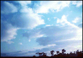
Figure 1-1. Cumulus Clouds.

Figure 1-2. Stratus Clouds.
(1) The two types of precipitating low-level clouds are nimbostratus and stratocumulus (Figures 1-3 and 1-4).
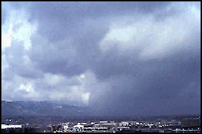
Figure 1-3. Nimbostratus Clouds.
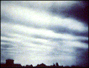
Figure 1-4. Stratocumulus Clouds.
(a) Nimbostratus clouds are dark, low-level clouds accompanied by light to moderately falling precipitation. The sun or moon is not visible through nimbostratus clouds, which distinguishes them from mid-level altostratus clouds. Because of the fog and falling precipitation commonly found beneath and around nimbostratus clouds, the cloud base is typically extremely diffuse and difficult to accurately determine.
(b) Stratocumulus clouds generally appear as a low, lumpy layer of clouds that is sometimes accompanied by weak precipitation. Stratocumulus vary in color from dark gray to light gray and may appear as rounded masses with breaks of clear sky in between. Because the individual elements of stratocumulus are larger than those of altocumulus, deciphering between the two cloud types is easier. With your arm extended toward the sky, altocumulus elements are about the size of a thumbnail while stratocumulus are about the size of a fist.
(2) Low-level clouds may be identified by their height above nearby surrounding relief of known elevation. Most precipitation originates from low-level clouds because rain or snow usually evaporate before reaching the ground from higher clouds. Low-level clouds usually indicate impending precipitation, especially if the cloud is more than 3,000 feet thick. (Clouds that appear dark at their bases are more than 3,000 feet thick.)
b. Mid-Level Clouds. Mid-level clouds (between 6,500 to 20,000 feet) have a prefix of alto. Middle clouds appear less distinct than low clouds because of their height. Alto clouds with sharp edges are warmer because they are composed mainly of water droplets. Cold clouds, composed mainly of ice crystals and usually colder than -30 degrees F, have distinct edges that grade gradually into the surrounding sky. Middle clouds usually indicate fair weather, especially if they are rising over time. Lowering middle clouds indicate potential storms, though usually hours away. There are two types of mid-level clouds, altocumulus and altostratus clouds (Figures 1-5 and 1-6).

Figure 1-5. Altocumulus.
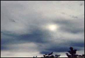
Figure 1-6. Altostratus.
(1) Altocumulus clouds can appear as parallel bands or rounded masses. Typically a portion of an altocumulus cloud is shaded, a characteristic which makes them distinguishable from high-level cirrocumulus. Altocumulus clouds usually form in advance of a cold front. The presence of altocumulus clouds on a warm humid summer morning is commonly followed by thunderstorms later in the day. Altocumulus clouds that are scattered rather than even, in a blue sky, are called "fair weather" cumulus and suggest arrival of high pressure and clear skies.
(2) Altostratus clouds are often confused with cirrostratus. The one distinguishing feature is that a halo is not observed around the sun or moon. With altostratus, the sun or moon is only vaguely visible and appears as if it were shining through frosted glass.
c. High-Level Clouds. High-level clouds (more than 20,000 feet above ground level) are usually frozen clouds, indicating air temperatures at that elevation below -30 degrees Fahrenheit, with a fibrous structure and blurred outlines. The sky is often covered with a thin veil of cirrus that partly obscures the sun or, at night, produces a ring of light around the moon. The arrival of cirrus indicates moisture aloft and the approach of a traveling storm system. Precipitation is often 24 to 36 hours away. As the storm approaches, the cirrus thickens and lowers, becoming altostratus and eventually stratus. Temperatures are warm, humidity rises, and winds become southerly or south easterly. The two types of high-level clouds are cirrus and cirrostratus (Figure 1-7 and Figure 1-8).
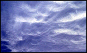
Figure 1-7. Cirrus.
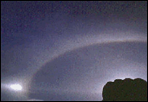
Figure 1-8. Cirrostratus.
(1) Cirrus clouds are the most common of the high-level clouds. Typically found at altitudes greater than 20,000 feet, cirrus are composed of ice crystals that form when super-cooled water droplets freeze. Cirrus clouds generally occur in fair weather and point in the direction of air movement at their elevation. Cirrus can be observed in a variety of shapes and sizes. They can be nearly straight, shaped like a comma, or seemingly all tangled together. Extensive cirrus clouds are associated with an approaching warm front.
(2) Cirrostratus clouds are sheet-like, high-level clouds composed of ice crystals. They are relatively transparent and can cover the entire sky and be up to several thousand feet thick. The sun or moon can be seen through cirrostratus. Sometimes the only indication of cirrostratus clouds is a halo around the sun or moon. Cirrostratus clouds tend to thicken as a warm front approaches, signifying an increased production of ice crystals. As a result, the halo gradually disappears and the sun or moon becomes less visible.
d. Vertical-Development Clouds. Clouds with vertical development can grow to heights in excess of 39,000 feet, releasing incredible amounts of energy. The two types of clouds with vertical development are fair weather cumulus and cumulonimbus.
(1) Fair weather cumulus clouds have the appearance of floating cotton balls and have a lifetime of 5 to 40 minutes. Known for their flat bases and distinct outlines, fair weather cumulus exhibit only slight vertical growth, with the cloud tops designating the limit of the rising air. Given suitable conditions, however, these clouds can later develop into towering cumulonimbus clouds associated with powerful thunderstorms. Fair weather cumulus clouds are fueled by buoyant bubbles of air known as thermals that rise up from the earth�s surface. As the air rises, the water vapor cools and condenses forming water droplets. Young fair weather cumulus clouds have sharply defined edges and bases while the edges of older clouds appear more ragged, an artifact of erosion. Evaporation along the cloud edges cools the surrounding air, making it heavier and producing sinking motion outside the cloud. This downward motion inhibits further convection and growth of additional thermals from down below, which is why fair weather cumulus typically have expanses of clear sky between them. Without a continued supply of rising air, the cloud begins to erode and eventually disappears.
(2) Cumulonimbus clouds are much larger and more vertically developed than fair weather cumulus (Figure 1-9). They can exist as individual towers or form a line of towers called a squall line. Fueled by vigorous convective updrafts, the tops of cumulonimbus clouds can reach 39,000 feet or higher. Lower levels of cumulonimbus clouds consist mostly of water droplets while at higher elevations, where the temperatures are well below freezing, ice crystals dominate the composition. Under favorable conditions, harmless fair weather cumulus clouds can quickly develop into large cumulonimbus associated with powerful thunderstorms known as super-cells. Super-cells are large thunderstorms with deep rotating updrafts and can have a lifetime of several hours. Super-cells produce frequent lightning, large hail, damaging winds, and tornadoes. These storms tend to develop during the afternoon and early evening when the effects of heating from the sun are the strongest.
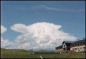
Figure 1-9. Cumulonimbus.
e. Other Cloud Types. These clouds are a collection of miscellaneous types that do not fit into the previous four groups. They are orographic clouds, lenticulars, and contrails.
(1) Orographic clouds develop in response to the forced lifting of air by the earth�s topography. Air passing over a mountain oscillates up and down as it moves downstream. Initially, stable air encounters a mountain, is lifted upward, and cools. If the air cools to its saturation temperature during this process, the water vapor condenses and becomes visible as a cloud. Upon reaching the mountain top, the air is heavier than the environment and will sink down the other side, warming as it descends. Once the air returns to its original height, it has the same buoyancy as the surrounding air. However, the air does not stop immediately because it still has momentum carrying it downward. With continued descent, the air becomes warmer then the surrounding air and accelerates back upwards towards its original height. Another name for this type of cloud is the lenticular cloud.
(2) Lenticular clouds are cloud caps that often form above pinnacles and peaks, and usually indicate higher winds aloft (Figure 1-10). Cloud caps with a lens shape, similar to a "flying saucer," indicate extremely high winds (over 40 knots). Lenticulars should always be watched for changes. If they grow and descend, bad weather can be expected.
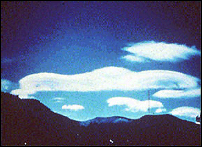
Figure 1-10. Linticular.
(3) Contrails are clouds that are made by water vapor being inserted into the upper atmosphere by the exhaust of jet engines (Figure 1-11). Contrails evaporate rapidly in fair weather. If it takes longer than two hours for contrails to evaporate, then there is impending bad weather (usually about 24 hours prior to a front).
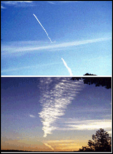
Figure 1-11. Contrails.
f. Cloud Interpretation. Serious errors can occur in interpreting the extent of cloud cover, especially when cloud cover must be reported to another location. Cloud cover always appears greater on or near the horizon, especially if the sky is covered with cumulus clouds, since the observer is looking more at the sides of the clouds rather than between them. Cloud cover estimates should be restricted to sky areas more than 40 degrees above the horizon�that is, to the local sky. Assess the sky by dividing the 360 degrees of sky around you into eighths. Record the coverage in eighths and the types of clouds observed.
Fronts
Fronts occur when two air masses of different moisture and temperature contents meet. One of the indicators that a front is approaching is the progression of the clouds. The four types of fronts are warm, cold, occluded, and stationary.
a. Warm Front. A warm front occurs when warm air moves into and over a slower or stationary cold air mass. Because warm air is less dense, it will rise up and over the cooler air. The cloud types seen when a warm front approaches are cirrus, cirrostratus, nimbostratus (producing rain), and fog. Occasionally, cumulonimbus clouds will be seen during the summer months.
b. Cold Front. A cold front occurs when a cold air mass overtakes a slower or stationary warm air mass. Cold air, being more dense than warm air, will force the warm air up. Clouds observed will be cirrus, cumulus, and then cumulonimbus producing a short period of showers.
c. Occluded Front. Cold fronts generally move faster than warm fronts. The cold fronts eventually overtake warm fronts and the warm air becomes progressively lifted from the surface. The zone of division between cold air ahead and cold air behind is called a "cold occlusion." If the air behind the front is warmer than the air ahead, it is a warm occlusion. Most land areas experience more occlusions than other types of fronts. The cloud progression observed will be cirrus, cirrostratus, altostratus, and nimbostratus. Precipitation can be from light to heavy.
d. Stationary Front. A stationary front is a zone with no significant air movement. When a warm or cold front stops moving, it becomes a stationary front. Once this boundary begins forward motion, it once again becomes a warm or cold front. When crossing from one side of a stationary front to another, there is typically a noticeable temperature change and shift in wind direction. The weather is usually clear to partly cloudy along the stationary front.
Temperature
Normally, a temperature drop of 3 to 5 degrees Fahrenheit for every 1,000 feet gain in altitude is encountered in motionless air. For air moving up a mountain with condensation occurring (clouds, fog, and precipitation), the temperature of the air drops 3.2 degrees Fahrenheit with every 1,000 feet of elevation gain. For air moving up a mountain with no clouds forming, the temperature of the air drops 5.5 degrees Fahrenheit for every 1,000 feet of elevation gain.
a. An expedient to this often occurs on cold, clear, calm mornings. During a troop movement or climb started in a valley, higher temperatures may often be encountered as altitude is gained. This reversal of the normal cooling with elevation is called temperature inversion. Temperature inversions are caused when mountain air is cooled by ice, snow, and heat loss through thermal radiation. This cooler, denser air settles into the valleys and low areas. The inversion continues until the sun warms the surface of the earth or a moderate wind causes a mixing of the warm and cold layers. Temperature inversions are common in the mountainous regions of the arctic, subarctic, and mid-latitudes.
b. At high altitudes, solar heating is responsible for the greatest temperature contrasts. More sunshine and solar heat are received above the clouds than below. The important effect of altitude is that the sun�s rays pass through less of the atmosphere and more direct heat is received than at lower levels, where solar radiation is absorbed and reflected by dust and water vapor. Differences of 40 to 50 degrees Fahrenheit may occur between surface temperatures in the shade and surface temperatures in the sun. This is particularly true for dark metallic objects. The difference in temperature felt on the skin between the sun and shade is normally 7 degrees Fahrenheit. Special care must be taken to avoid sunburn and snow blindness. Besides permitting rapid heating, the clear air at high altitudes also favors rapid cooling at night. Consequently, the temperature rises fast after sunrise and drops quickly after sunset. Much of the chilled air drains downward, due to convection currents, so that the differences between day and night temperatures are greater in valleys than on slopes.
c. Local weather patterns force air currents up and over mountaintops. Air is cooled on the windward side of the mountain as it gains altitude, but more slowly (3.2 degrees Fahrenheit per 1,000 feet) if clouds are forming due to heat release when water vapor becomes liquid. On the leeward side of the mountain, this heat gained from the condensation on the windward side is added to the normal heating that occurs as the air descends and air pressure increases. Therefore, air and winds on the leeward slope are considerably warmer than on the windward slope, which is referred to as Chinook winds. The heating and cooling of the air affects planning considerations primarily with regard to the clothing and equipment needed for an operation.
Weather Forecasting
The use of a portable aneroid barometer, thermometer, wind meter, and hygrometer help in making local weather forecasts. Reports from other localities and from any weather service, including USAF, USN, or the National Weather Bureau, are also helpful. Weather reports should be used in conjunction with the locally observed current weather situation to forecast future weather patterns.
a. Weather at various elevations may be quite different because cloud height, temperature, and barometric pressure will all be different. There may be overcast and rain in a lower area, with mountains rising above the low overcast into warmer clear weather.
b. To be effective, a forecast must reach the small-unit leaders who are expected to utilize weather conditions for assigned missions. Several different methods can be used to create a forecast. The method a forecaster chooses depends upon the forecaster�s experience, the amount of data available, the level of difficulty that the forecast situation presents, and the degree of accuracy needed to make the forecast. The five ways to forecast weather are:
(1) Persistence Method. "Today equals tomorrow" is the simplest way of producing a forecast. This method assumes that the conditions at the time of the forecast will not change; for example, if today was hot and dry, the persistence method predicts that tomorrow will be the same.
(2) Trends Method. "Nowcasting" involves determining the speed and direction of fronts, high- and low-pressure centers, and clouds and precipitation. For example, if a cold front moves 300 miles during a 24-hour period, we can predict that it will travel 300 miles in another 24-hours.
(3) Climatology Method. This method averages weather statistics accumulated over many years. This only works well when the pattern is similar to the following years.
(4) Analog Method. This method examines a day�s forecast and recalls a day in the past when the weather looked similar (an analogy). This method is difficult to use because finding a perfect analogy is difficult.
(5) Numerical Weather Prediction. This method uses computers to analyze all weather conditions and is the most accurate of the five methods.
Recording Data
An accurate observation is essential in noting trends in weather patterns. Ideally, under changing conditions, trends will be noted in some weather parameters. However, this may not always be the case. A minor shift in the winds may signal an approaching storm.
a. Wind Direction. Assess wind direction as a magnetic direction from which the wind is blowing.
b. Wind Speed. Assess wind speed in knots.
(1) If an anemometer is available, assess speed to the nearest knot.
(2) If no anemometer is available, estimate the speed in knots. Judge the wind speed by the way objects, such as trees, bushes, tents, and so forth, are blowing.
c. Visibility in Meters. Observe the farthest visible major terrain or man-made feature and determine the distance using any available map.
d. Present Weather. Include any precipitation or obscuring weather. The following are examples of present weather:
- Rain � continuous and steady liquid precipitation that will last at least one hour.
- Rain showers � short-term and potentially heavy downpours that rarely last more than one hour.
- Snow � continuous and steady frozen precipitation that will last at least one hour.
- Snow showers � short-term and potentially heavy frozen downpours that rarely last more than one hour.
- Fog, haze � obstructs visibility of ground objects.
- Thunderstorms � a potentially dangerous storm. Thunderstorms will produce lightning, heavy downpours, colder temperatures, tornadoes (not too frequently), hail, and strong gusty winds at the surface and aloft. Winds commonly exceed 35 knots.
e. Total Cloud Cover. Assess total cloud cover in eighths. Divide the sky into eight different sections measuring from horizon to horizon. Count the sections with cloud cover, which gives the total cloud cover in eighths. (For example, if half of the sections are covered with clouds, total cloud cover is 4/8.)
f. Ceiling Height. Estimate where the cloud base intersects elevated terrain. Note if bases are above all terrain. If clouds are not touching terrain, then estimate to the best of your ability.
g. Temperature. Assess temperature with or without a thermometer.
(1) With a thermometer, assess temperature in degrees Celsius (use Fahrenheit only if Celsius conversion is not available). To convert Fahrenheit to Celsius: C = F minus 32 times .55. To convert Celsius to Fahrenheit: F = 1.8 times C plus 32.
Example: 41 degrees F � 32 x .55 = 5 degrees C.
5 degrees C x 1.8 + 32 = 41 degrees F.
(2) Without a thermometer, estimate temperature as above or below freezing (0°C), as well as an estimated temperature.
h. Pressure Trend. With a barometer or altimeter, assess the pressure trend.
(1) A high pressure moving in will cause altimeters to indicate lower elevation.
(2) A low pressure moving in will cause altimeters to indicate higher elevation.
i. Observed Weather. Note changes or trends in observed weather conditions.
(1) Deteriorating trends include:
- Marked wind direction shifts. A high pressure system wind flows clockwise. A low pressure system wind flows counterclockwise. The closer the isometric lines are, the greater the differential of pressure (greater wind speeds).
- Marked wind speed increases.
- Changes in obstructions to visibility.
- Increasing cloud coverage.
- Increase in precipitation. A steady drizzle is usually a long-lasting rain.
- Lowering cloud ceilings.
- Marked cooler temperature changes, which could indicate that a cold front is passing through.
- Marked increase in humidity.
- Decreasing barometric pressure, which indicates a lower pressure system is moving through the area.
(2) Improving trends include:
- Steady wind direction, which indicates no change in weather systems in the area.
- Decreasing wind speeds.
- Clearing of obstructions to visibility.
- Decreasing or ending precipitation.
- Decreasing cloud coverage.
- Increasing height of cloud ceilings.
- Temperature changes slowly warmer.
- Humidity decreases.
- Increasing barometric pressure, which indicates that a higher pressure system is moving through the area.
j. Update. Continue to evaluate observed conditions and update the forecast.
Ultimate Survival Knife & Kit |
List Price: 61.99 Our Price: 39.95 |
This 15 inch survival knife with drop point blade features a thick quality stainless steel blade with serrated top edge. Textured and ribbed solid metal handle and guard. Nylon sheath. Survival kit includes a hollow grip with a compass top to store items within the knife itself, as well as additional pouches on the sheath to hold the rest. Complete survival kit. Click Here to Buy the Survival Knife Now. |
|
